
Proposals
A sustainable, mixed-use extension to the north of Sudbury
We are bringing forward plans for a new neighbourhood of up to 750 high-quality homes, including 35% affordable homes, alongside education, employment, retail and care uses. Approximately 16 hectares of public open space, new walking and cycling routes, sustainable drainage and habitat enhancements will also be integrated into the heart of our proposals.
Our vision is to create a place where people can live, work and access everyday services in one well-connected, landscape-led setting.
Key features
Designed to meet the needs of the local community
The landscape-led proposal offers an exciting, sustainable development with a number of different benefits and features for Sudbury. The emerging proposals include:
- A mix of up to 750 high-quality new homes, forming a sustainable extension to the north of Sudbury.
- 35% affordable housing, helping meet identified local needs across Babergh District.
- Land reserved for a primary school with early years provision.
- Land for employment uses including retail, hotel, care home, office, industrial and warehousing.
- Approximately 16ha of public open space, creating a landscape-led development with extensive green infrastructure.
- At least a 10% biodiversity net gain, enhancing habitats and supporting local wildlife.
- New walking and cycling routes, connecting the development with the wider Chilton Woods community and surrounding Public Rights of Way (PROWs).
- A comprehensive Sustainable Drainage System (SuDS), designed to manage surface water responsibly.
- Energy‑efficient homes, designed to meet modern environmental standards.
- Provision of new household waste facility.

The site
A well-connected location on the northern edge of Sudbury
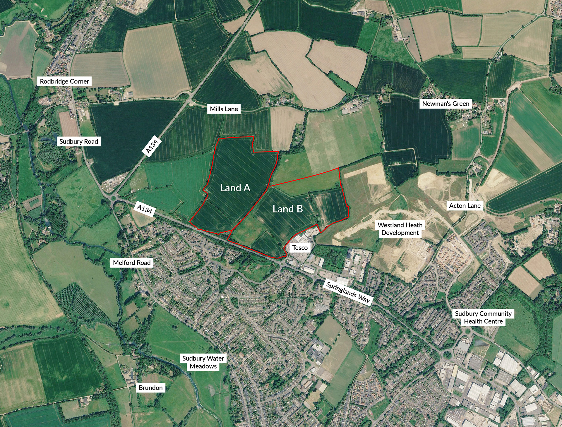
The site lies on the northern edge of Sudbury, immediately north of the A134. It comprises approximately 45 hectares (111 acres) of agricultural land extending towards Mill Lane and forms part of the strategic allocation known as Chilton Woods.
Woodhall Business Park and Tesco Superstore are located to the south-east, whilst Sudbury town centre lies to the south beyond the A134. The site is also well-connected to an established network of Public Rights of Way running through and around the site.
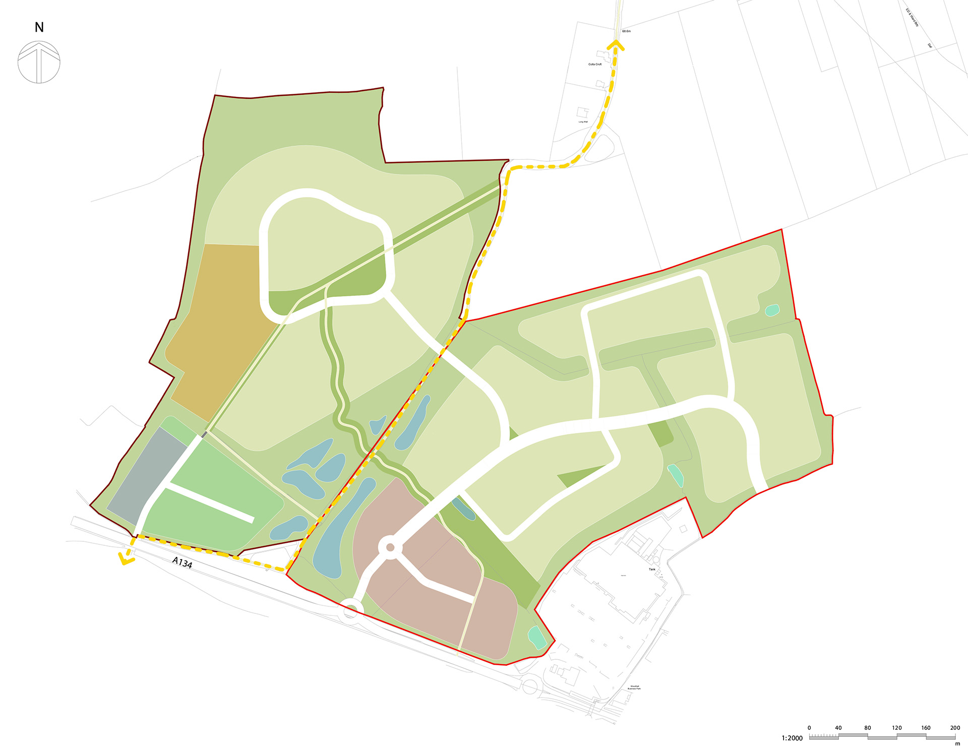
 Land A boundary (23.57 Ha)
 Land B boundary (21.38 Ha)
 Net developable residential area
 Retail land
 Indicative location for proposed primary school
 Indicative location for employment land
 Indicative location for refuse centre
 Public open space
 Pocket parks
 Existing ponds
 Proposed SuDS basins
 Proposed vehicular movement routes
 Proposed active travel routes
 Proposed emergency vehicle access
 Public Right of Way
New homes
Helping to meet the housing needs of Sudbury and the wider Babergh district
The proposals would deliver up to 750 homes in a mix of sizes, types and tenures. The detailed housing mix will be developed through the planning process to respond to local needs and create a balanced new community. New homes will be designed to meet current Building Regulations and high standards of energy efficiency.
A total of 35% of the homes are proposed as affordable homes, across a range of tenures for people whose needs are not met by the open market. Babergh District Council cannot currently demonstrate a five-year supply of deliverable housing sites, and the proposals would help address that shortfall in a location already identified, in part, for strategic growth.

Neighbourhood
A place to live, learn and work
The proposals are about much more than housing. Land would be provided for a new primary school and early years facilities, helping support educational needs arising from the wider Sudbury community.
The neighbourhood would also include retail and employment land, a care home, a hotel and a household waste recycling centre. These uses would create new jobs – both during construction and post-construction phases, provide convenient local services and help support Sudbury town centre and the wider local economy.
The commercial elements of the proposals are already attracting interest from established foodstore, café, hotel and care operators. This early interest indicates demand for the proposed uses and the potential to deliver new services and employment opportunities for the local community.

Landscaping & open space
A landscape-led approach at the heart of our development
Approximately 16 hectares of open space would form a defining feature of the new neighbourhood. Existing trees, hedgerows, ponds and other landscape features will be retained and enhanced wherever practical, supported by new tree and hedgerow planting as well as a network of green edges around the majority of the development.
Development blocks will be carefully positioned to face outwards towards these green edges, creating an attractive relationship between new homes and the surrounding landscape. A particularly strong green edge to the north of the site will provide an important visual buffer and help integrate the neighbourhood into its wider setting.
New habitats, species-rich grassland, green corridors and sustainable drainage features will help the proposals achieve at least 10% Biodiversity Net Gain. Existing Public Rights of Way, including the bridleway through the site, will be integrated with new walking and cycling routes to make the landscape accessible to existing and future residents.

Site access & active travel
Connecting Chilton Woods to the surrounding area
The principal access is proposed from a new roundabout on the A134, similar to the access already consented for the wider Chilton Woods development. A spine road through the site would create the opportunity to connect the A134 with the existing Chilton Woods road network, improving route choice and helping reduce pressure on Acton Lane. This would deliver one of the key policy objectives of the Local Plan which the original planning consent failed to secure. A Transport Assessment will accompany the outline planning application to demonstrate the impact of the development on existing road infrastructure in the surrounding areas.
A separate junction from the A134 is proposed for the household waste recycling centre and employment area.
The mixed-use masterplan will place homes, education, shops, employment and green space within one connected neighbourhood, helping more everyday journeys to be made on foot, by bicycle or by public transport. New pedestrian and cycle routes would connect with the wider Chilton Woods development and existing Public Rights of Way, while the spine road could also create the opportunity for a bus route through the wider strategic development.
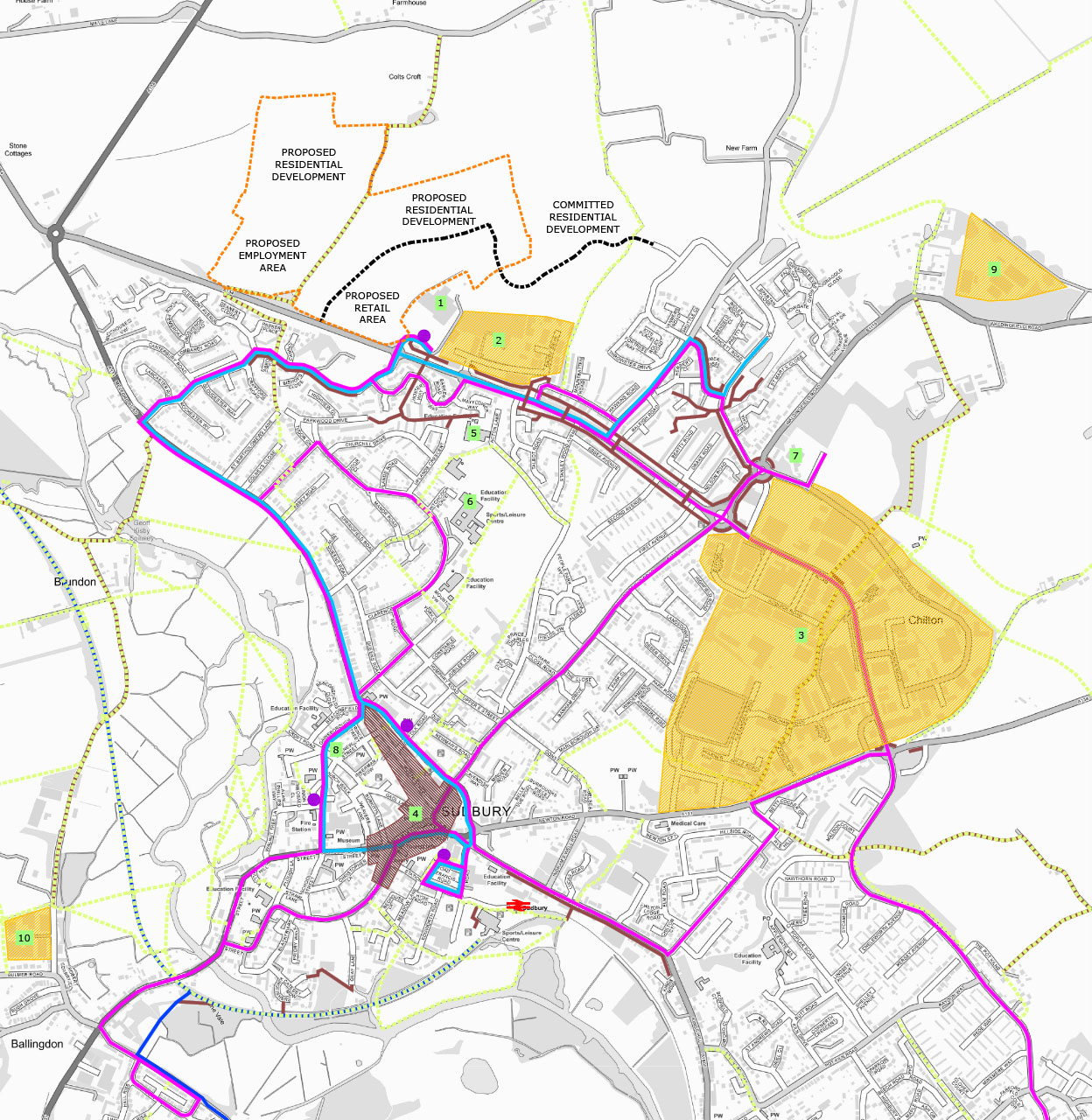
 Selected existing bus stops
 Rail station
 Indicative site boundary
 New/committed road (indicative)
 Public rights of way
 National cycle route 13
 Other off-road cycle routes
 Bus route 49
 Bus route 700
 Retail area
 Employment area
 Food superstore
 Woodhall Industrial Estate
 Chilton Industrial Estate
 Sudbury town centre
 Woodhall Primary School
 Orminston Sudbury Academy
 Sudbury Community Health Centre
 The Croft Dental Surgery
 Chilton Airfield (Employment)
 Bulmer Road Industrial Estate
Drainage
Managing surface water responsibly
The site is wholly within Flood Zone 1, where the probability of river or sea flooding is very low. A detailed Flood Risk Assessment and drainage strategy will accompany the outline planning application to demonstrate that the development will not increase flood risk on the site or elsewhere.
A robust Sustainable Urban Drainage System (SuDS), including landscaped basins and other features, will slow and store surface water and provide new habitat and landscape value. The system will be designed to reflect the site’s ground conditions and existing drainage routes.
Timeline
How will the project move forward?
Timeline is subject to change due to planning and consultation.
September 2026
Public consultation.
Autumn 2026
Review consultation responses and revise the scheme where appropriate.
Winter 2026
Targeted submission of outline planning application to Babergh District Council.
Spring / Summer 2027
Currently anticipated determination of outline planning application by Babergh District Council’s Planning Committee.